

You're now following
Error following user.
This user does not allow users to follow them.
You are already following this user.
Your membership plan only allows 0 follows. Upgrade here.
Successfully unfollowed
Error unfollowing user.
You have successfully recommended
Error recommending user.
Something went wrong. Please refresh the page and try again.
Email successfully verified.

acarigua, venezuela
It's currently 7:45 AM here
Joined March 15, 2022
1 Recommendation
Daniel L.
@Danlp81
4.8
4.8
85%
85%
acarigua, venezuela
93%
Jobs Completed
100%
On Budget
100%
On Time
13%
Repeat Hire Rate
GIS Expert - Civil Engineer and Spatial Analysis
Contact Daniel L. about your job
Log in to discuss any details over chat.
Portfolio
Portfolio

CAD data integration in ArcGIS Pro and 3D modeling
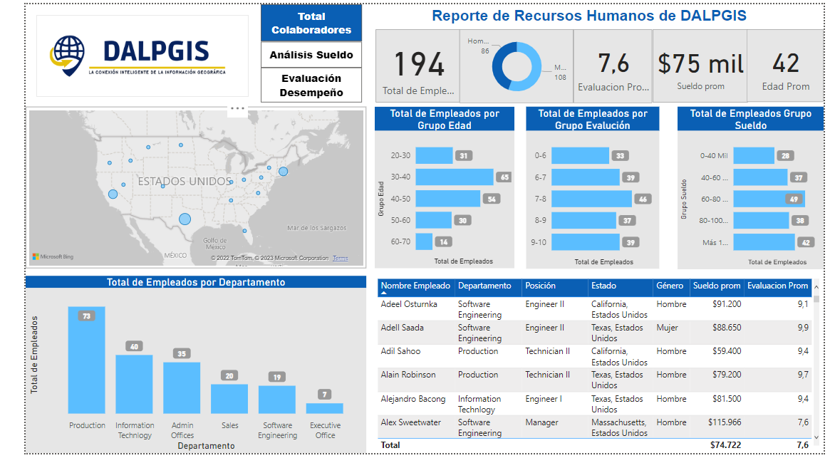

Dashboard with Power Bi

Dashboard with Power Bi

Dashboard with Power Bi

Dashboard with Power Bi

Dashboard with Power Bi

Dashboard with Power Bi
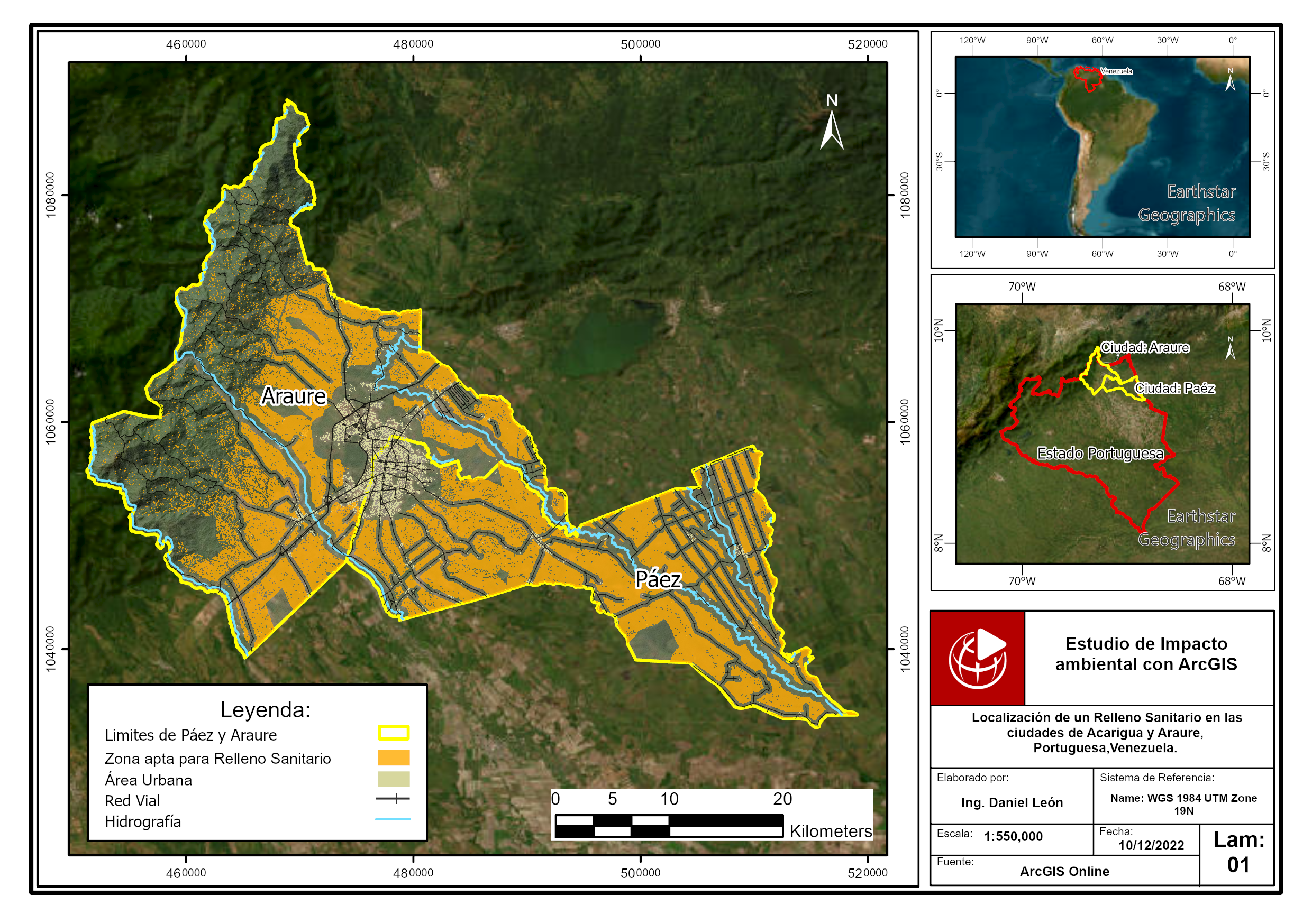

Location of a sanitary landfill through multicriteria analys

Location of a sanitary landfill through multicriteria analys
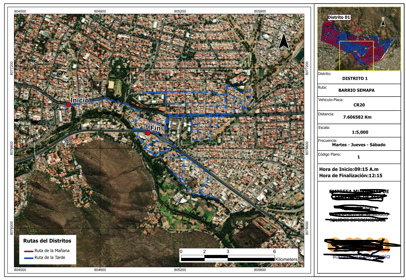

Series of maps to plan cleaning routes
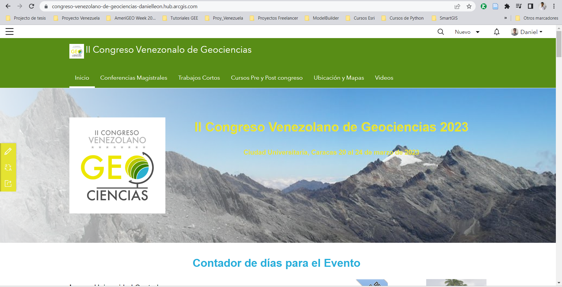

Web solution for events with ArcGIS

Web solution for events with ArcGIS

Web solution for events with ArcGIS

Web solution for events with ArcGIS
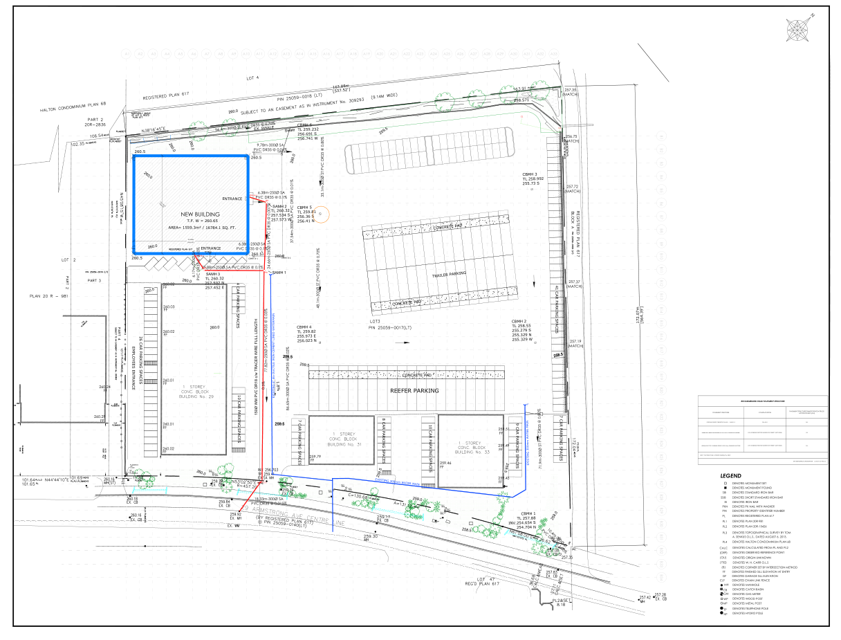

Site plan design for construction projects

Site plan design for construction projects

Site plan design for construction projects

Site plan design for construction projects

Site plan design for construction projects

Site plan design for construction projects
CAD data integration in ArcGIS Pro and 3D modeling
Dashboard with Power Bi
Dashboard with Power Bi
Dashboard with Power Bi
Dashboard with Power Bi
Dashboard with Power Bi
Dashboard with Power Bi
Location of a sanitary landfill through multicriteria analys
Location of a sanitary landfill through multicriteria analys
Series of maps to plan cleaning routes
Web solution for events with ArcGIS
Web solution for events with ArcGIS
Web solution for events with ArcGIS
Web solution for events with ArcGIS
Site plan design for construction projects
Site plan design for construction projects
Site plan design for construction projects
Site plan design for construction projects
Site plan design for construction projects
Site plan design for construction projects
Reviews
Changes saved
Showing 1 - 5 out of 9 reviews
€100.00 EUR
Data Processing
Excel
Cartography & Maps
Geospatial
+1 more

•
$500.00 USD

•
€50.00 EUR
Data Processing
Excel
Cartography & Maps
Geospatial
+1 more
•
$200.00 USD
Excel
SPSS Statistics
ArcGIS
A
•
$200.00 USD
Data Processing
Excel
Cartography & Maps
Geospatial
+1 more
S

•
Experience
Applied Science Research Assistant
Sep 2021 - Present
Project Manager of Exposure and Seismic Vulnerability of Buildings Using Multispectral and UAV Imaging in Chosica, Peru.
Communications committee leader for AmeriGEO Week 2022.
Co-author of the "Manka Watikay" Project, where an analysis of the exposure of the Ollas Comunes to different types of threats was carried out.
Technical and logistical support with multidisciplinary representatives in international organizations and governments.
Education
Technician in Topography
(2 years)
Civil Engineer
(6 years)
Contact Daniel L. about your job
Log in to discuss any details over chat.
Verifications
Top Skills
Browse Similar Freelancers
Browse Similar Showcases
Invite sent successfully!
Thanks! We’ve emailed you a link to claim your free credit.
Something went wrong while sending your email. Please try again.
Copy to clipboard failed, please try again after adjusting your permissions.
Copied to clipboard.
Loading preview
Permission granted for Geolocation.
Your login session has expired and you have been logged out. Please log in again.